Datei:View of the Margaret Hunt Hill Bridge, a Santiago Calatrava-designed bridge over the Trinity River in Dallas, Texas LCCN2014632135.tif
Originaldatei (6.559 × 3.684 Pixel, Dateigröße: 164,55 MB, MIME-Typ: image/tiff)
Diese Datei stammt aus Wikimedia Commons und kann von anderen Projekten verwendet werden. Die Beschreibung von deren Dateibeschreibungsseite wird unten angezeigt.
Beschreibung
BeschreibungView of the Margaret Hunt Hill Bridge, a Santiago Calatrava-designed bridge over the Trinity River in Dallas, Texas LCCN2014632135.tif |
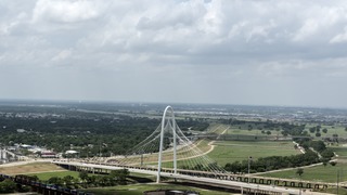
English: Title: View of the Margaret Hunt Hill Bridge, a Santiago Calatrava-designed bridge over the Trinity River in Dallas, Texas
Physical description: 1 photograph : digital, tiff file, color. Notes: The bridge is named for Margaret Hunt Hill, a Dallas entrepreneur and philanthropist, who was the daughter of legendary oilman H.L. Hunt.Construction on the bridge began in spring 2007 with the steel manufactured in an Italian steel factory often used by Calatrava to realize his designs. It connects Texas Spur 366 (the Woodall Rodgers Freeway) downtown to Singleton Boulevard in west Dallas.; Title, date, and keywords based on information provided by the photographer.; Gift; The Lyda Hill Foundation; 2014; (DLC/PP-2014:054).; Forms part of: Lyda Hill Texas Collection of Photographs in Carol M. Highsmith's America Project in the Carol M. Highsmith Archive.; Credit line: The Lyda Hill Texas Collection of Photographs in Carol M. Highsmith's America Project, Library of Congress, Prints and Photographs Division. |
||||||||||||||||||||||||||
Datum | Aufgenommen am 11. Mai 2014, 14:26 (gemäß Exif-Daten) | ||||||||||||||||||||||||||
Quelle |
Library of Congress
|
||||||||||||||||||||||||||
Urheber |
creator QS:P170,Q5044454 |
||||||||||||||||||||||||||
Genehmigung (Weiternutzung dieser Datei) |
No known restrictions on publication.
|
Kameraposition | 32° 46′ 40,82″ N, 96° 48′ 34,51″ W | Dieses und weitere Bilder auf OpenStreetMap | 32.778005; -96.809587 |
---|
Lizenz
Public domainPublic domainfalsefalse |
Dieses Werk stammt aus der Carol M. Highsmith Archive-Sammlung der Library of Congress. Laut der Bibliothek gibt es keine bekannten Copyright-Einschränkungen in der Verwendung dieses Werkes. Carol M. Highsmith has stipulated that her photographs are in the public domain. Photographs of sculpture or other works of art may be restricted by the copyright of the artist; see Commons:FOP US#Artworks and sculptures for more information. |
In dieser Datei abgebildete Objekte
Motiv
32°46'40.818"N, 96°48'34.513"W
Dateiversionen
Klicke auf einen Zeitpunkt, um diese Version zu laden.
Version vom | Vorschaubild | Maße | Benutzer | Kommentar | |
---|---|---|---|---|---|
aktuell | 08:47, 27. Sep. 2016 | 6.559 × 3.684 (164,55 MB) | wikimediacommons>Fæ | LOC 2014632135, Carol M. Highsmith collection. P727.21849 TIFF (164.5mb) |
Dateiverwendung
Die folgende Seite verwendet diese Datei:
Metadaten
Diese Datei enthält weitere Informationen, die in der Regel von der Digitalkamera oder dem verwendeten Scanner stammen. Durch nachträgliche Bearbeitung der Originaldatei können einige Details verändert worden sein.
Bildtitel | View of the Margaret Hunt Hill Bridge, a Santiago Calatrava-designed bridge over the Trinity River in Dallas, Texas. The bridge is named for Margaret Hunt Hill, a Dallas entrepreneur and philanthropist, who was the daughter of legendary oilman H. L. Hunt.
Construction on the bridge began in spring 2007 with the steel manufactured in an Italian steel factory often used by Calatrava to realize his designs. It connects Texas Spur 366 (the Woodall Rodgers Freeway) downtown to Singleton Boulevard in west Dallas. The cable-stayed bridge is 1,870 feet long with an apex-height of 400 feet. On June 26, 2010, the signature, 40-story center-support-arch was topped-off with a central curved span, providing an additional feature to the Dallas skyline, as it can now be seen from many miles away from several directions. |
---|---|
Hersteller | NIKON CORPORATION |
Modell | NIKON D800 |
Fotograf | Photographer: Carol M. Highsmith |
Belichtungsdauer | 1/400 Sekunden (0,0025) |
Blende | f/10 |
Film- oder Sensorempfindlichkeit (ISO) | 100 |
Erfassungszeitpunkt | 14:26, 11. Mai 2014 |
Brennweite | 70 mm |
Geografische Breite | 32° 46′ 40,82″ N |
Geografische Länge | 96° 48′ 34,51″ W |
Höhe | 299 Meter über dem Meeresspiegel |
Breite | 6.559 px |
Höhe | 3.684 px |
Bits pro Farbkomponente |
|
Art der Kompression | LZW |
Pixelzusammensetzung | RGB |
Kameraausrichtung | Normal |
Anzahl Komponenten | 3 |
Anzahl Zeilen pro Streifen | 6 |
Horizontale Auflösung | 300 dpi |
Vertikale Auflösung | 300 dpi |
Datenausrichtung | Grobformat |
Software | Ver.1.02 |
Speicherzeitpunkt | 20:04, 12. Mai 2014 |
Belichtungsprogramm | Manuell |
Exif-Version | 2.21 |
Digitalisierungszeitpunkt | 14:26, 11. Mai 2014 |
APEX-Belichtungszeitwert | 8,643856 |
APEX-Blendenwert | 6,643856 |
Belichtungsvorgabe | 0 |
Größte Blende | 3 APEX (f/2,83) |
Messverfahren | Muster |
Lichtquelle | Unbekannt |
Blitz | kein Blitz, Blitz abgeschaltet |
Erfassungszeitpunkt (1/100 s) | 4 |
Farbraum | Nicht kalibriert |
Sensorauflösung horizontal | 2.048,4022216797 |
Sensorauflösung vertikal | 2.048,4022216797 |
Einheit der Sensorauflösung | 3 |
Messmethode | Ein-Chip-Farbsensor |
Quelle der Datei | Digitale Standbildkamera |
Szenentyp | Normal |
Benutzerdefinierte Bildverarbeitung | Standard |
Belichtungsmodus | Manuelle Belichtung |
Weißabgleich | Automatisch |
Digitalzoom | 1 |
Brennweite (Kleinbildäquivalent) | 70 mm |
Aufnahmeart | Standard |
Verstärkung | Keine |
Kontrast | Normal |
Sättigung | Normal |
Schärfe | Normal |
Motiventfernung | Unbekannt |
GPS-Zeit | 19:26 |
Für die Messung benutzte Satelliten | 07 |
Geodätisches Referenzsystem | WGS84 |
GPS-Datum | 11. Mai 2014 |
GPS-Tag-Version | 0.0.3.2 |